Table of contents
Repolampi laavu and Ranua Wildlife Park nature trails
Repolampi laavu is perhaps the most easily accessible camping site in Ranua. Because of this, it is also highly suitable for families with small children. This “shed” is located in connection with the Ranua Zoo nature path, less than a kilometer from the Heinisuo road. The shed is easily accessible along a well-maintained walking path that works as a cross-country skiing trail during winter. In connection with the large shed, making fire is easy and the place is located right Repolampi (pond), which makes it possible to enjoy the beautiful pond and swamp landscapes. It is a good idea to bring your own firewood for the shed as these are not always provided by the town.

The zoo’s nature trail is a total of 3.4 kilometers long, and there is also a traditional hut, a firewood store, a dry toilet and nine nature sites presented on signposts. The entire route is illuminated, making it easy to visit the route even in the evening. In winter, the nature trail serves as a ski trail maintained by the municipality of Ranua.
Lake Ranua nature path

The Ranuanjärvi nature path runs on the northern shore of Lake Ranua. This is a so-called plug-in route, which means that in the route you must go back and forth if you want to arrive and leave at the same starting point. The starting and ending points of the route are the Christian Folk High School and the Laivala area. If you wish, you can also walk around the route, taking advantage of the road network found near the end point in Laivala.
The Ranuanjärvi hiking trail is about 7 kilometers long and easily accessible by any type of trekkers. There is also a possibility to make fire in the laavu of lake Ranua.
Koukku Äijä nature path
Koukku Äijä’s nature trail is located in Simojoki, between the village of Mauru and lake Peurajärvi, more than 30 kilometers from the center of the village of Ranua. You can start your trip on the nature trail from three different places: in Mauru from Alkulantie or Ruonalammentie and in Peurajärvi from Hermolantie.
The Koukku Äijä’s trail is about 8 kilometers long and about 2 kilometers of this trail has been equipped with duckboards between 2004 and 2007. Most of the duckboards are on the Peurajärvi side. The most used part of the nature trail is the area between Ruonalammentie and Suhankojoki, which is about half a mile long. There is also an unlocked hut located on the banks of the Suhanko River.
Litokaira camping and hiking area
The northern parts of Litokaira area are located inside the municipality of Ranua, and the southern parts of the area belong to Pudasjärvi. There is also a small piece of western Litokaira that is located on the side of Ii municipality.
On the Ranua side, the starting point for the trip is most likely going to be Papinpalo, from where you can proceed to destinations nearby such as the nature trail, the bird tower and Tervo shed.
The easiest way to get to the trails is by your own car. In the center of Ranua, turn off the Rovaniemi road (no. 78) to Heinisuontie, and after about 4 km drive, a dirt road branches off from the road, which leads Papinpalo. This road is driven for about 11.5 kilometers until you reach the Papinpalo parking area, where a signposted path to the Papinpalo bird tower and Tervo shed begins.
There are two deserted huts in the Litokaira hiking area – the Litjo desert hut and the Litokaira reindeer hut, as well as one shed and a campfire site.
The wilderness of Litokaira is a suitable excursion destination, especially for people who appreciate the peace of the wilderness and untouched nature. Basic knowledge of camping and hiking is really useful here as the area is not the most easily accessible.
Simojärvi and Soppana area

The Simojärvi hiking trail is an approximately 14.5-kilometer-long, easy-going route starting from the beginning of Korvajoki river. The wettest parts of the route have been equipped with duckboards. Along the route you can admire the lake landscapes, swamp areas and stunning open rock formations. The route can be started from the Matalakangas parking area.
When hiking in the area, it should be taken into account that some of the duckboards and the bridges on the route are already in fairly poor condition, which is why it is important to pay special attention to your own safety when hiking on the route. Services found on the hiking trail include Tuppilampi fire place, Korvajokisuu and Yli-Soppananjärvi areas with outdoor cooking areas and fire places and good opportunities for tenting. There is also a well in the Yli-Soppananjärvi camping area from which drinking water can be taken. Firewood is no longer delivered to the shed of Tuppilampi, so it is good to bring your own firewood with you.
The Paasonjärvi hiking trail (link to a map) is an approximately 11.3 km long route that runs through the old forest sanctuary. This route is also quite easy to navigate and the wettest parts of the trail are equipped with duckboards. Paasonjoki and Paha-Paasonjoki have bridges. The starting point of the route is along Teerivaarantie, near the Paasonjoki river.
With regard to the Paasonjärvi route, it should be noted that the route markings in the area are fairly poor and may be difficult to read. Some of the duckboards have already reached poor condition, which is why special care is needed in the area. Some of the bridges are also old and in poor condition and the same applies to the stairs down to Paasonjoki. The route also has a connection to the Paasonvaara observation trail and the Korouoma – Simojärvi hiking route.
The Paasonvaara lookout trail is an approximately 5 km long route that runs partly in connection with the Paasonjärvi hiking trail. The route is relatively easy, but the climb to Paasonvaara is reasonably challenging part and requires reasonable stamina from the climber. On the route, the hiker can walk and enjoy e.g. walking on the open rock, as well as the magnificent scenery that opens up from Paasovaara. The observation trail starts as a separate ring route from the Paasonjärvi hiking trail, close to Kosti’s Hut.
There are two fire pits on the route: Kosti’s hut in Paha-Paasonjärvi and Paasonjärvi lay-on.
Also on the Paasonvaara observation trail, attention must be paid to the condition of bridges and duckboards.

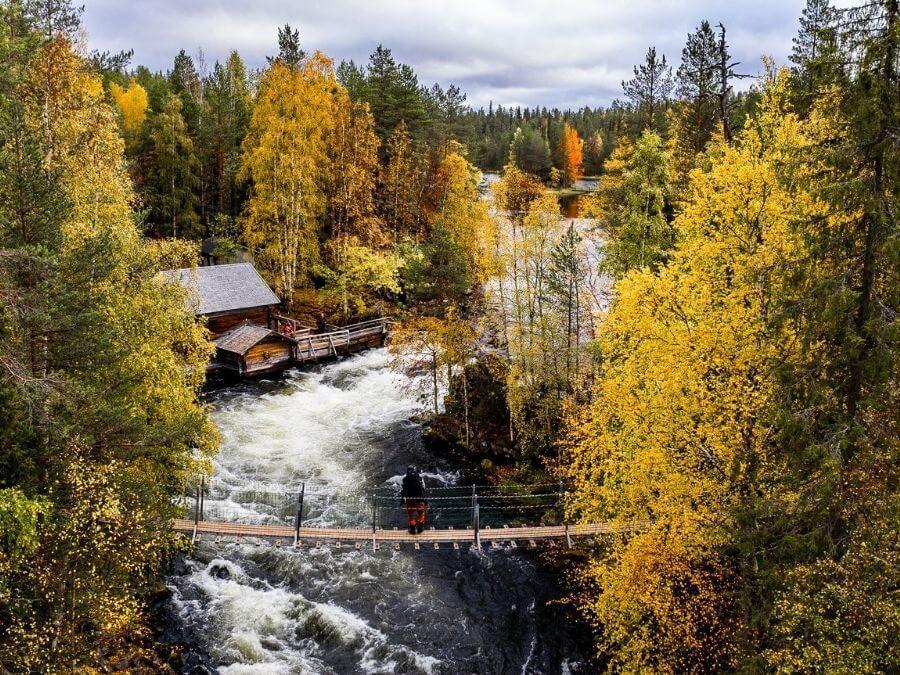
Auttiköngäs

Located on the Rovaniemi side, Auttiköngäs is one of the biggest attractions in Southern Lapland. Known for one of Finland’s most magnificent waterfalls, Auttiköngäs is located about an hour’s drive from Ranua and is a great destination for a daytrip for those staying either in Rovaniemi or Ranua.
In addition to crossing the magnificent waterfall, the nature trail in Auttiköngäs leads the visitor to the peace of the northern primeval forests and to the high high cliff observation tower, where it is possible to admire the fault of the old evergreen forests, and in autumn also the colors of the fall. Thanks to its versatility and stunning scenery, Auttiköngäs has become an excellent excursion destination all year round.
The 3.6 km of clearly signposted nature trail is an excellent hiking destination for families as well. During the excursion in Auttiköngäs, it is possible to stop, for example, for sausage frying in the shed or enjoy a warm cup of coffee, tea or juice in the much-lauded atmosphere of the traditional café.
Riisitunturi hiking routes and camping sites

Riisitunturi National Park in Posio is about an hour and a half drive from the village of Ranua. There are two main starting points for the area: the Riisitunturi car park, and Kirintövaara.
Various hiking and trekking routes can be found from Riisitunturi, which makes the national park a great hiking and camping destination for people of all ages. The lengths of the routes mainly vary from about 1.5 kilometers to the whole Riisitunturi route of about 29 kilometers. A total of about 85 km of marked trails and cross-country trails are available.
You can find out more about Riisitunturi’s summer time routes and more detailed information about them, for example on the Nationalparks’ website.
Korouoma hiking routes and camping sites

Korouoma, also located in Posio, is a valley about 30 km long in a northwest-southeast direction. It is part of a hundreds of millions of years old bedrock fracture zone. Korouoma is a great hiking destination all year round and it offers hikers and hikers a very diverse range of routes and activities. The most avid hiker can, if they wish, go around the entire 30 km long line or alternatively stay on the 5 km long Koronjää route, along which the three largest ice falls in the canyon also rise.
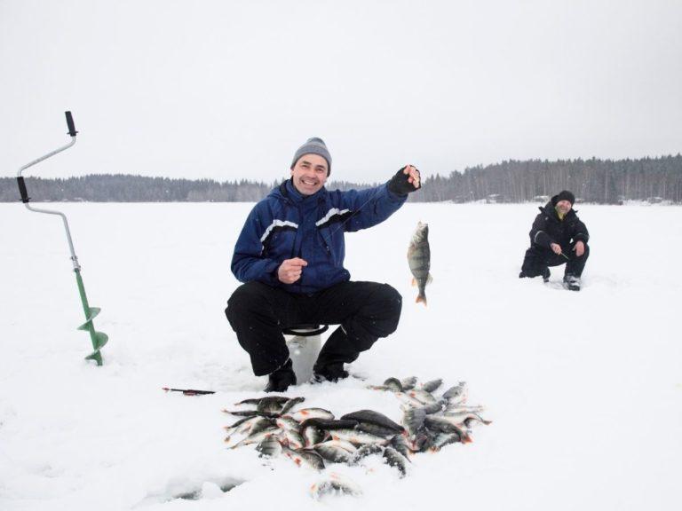
There is also a variety of things to do on the route, because in addition to hiking, it is possible to fish, observe birds, bike, pick berries and mushrooms, swim and even ice climb.
There are also commendable services in the Korouoma area, as there are e.g. day and deserted huts, and a total of 13 campfire sites and sheds. Camping equipment can be rented from Posio Tourist Information, for example.
Korouoma, about 80 kilometers from Ranua, can be reached in two ways, and the journey along both routes takes just over an hour. You can find more information about hiking in Korouoma from Nationalparks’ website.